Search results
Archive type
Content type
Related places
Languages
Scripts
Showing 1 to 15 of 50 results
-
Maps and Plans [Late 19th century-early 20th century]
Description: Late 19th and early 20th century. Probably to accompany sales of property. Hand drawn by surveyors. Extent and format of original…
-
Request for certifide map copy of Muslim burial ground
Request and grant of certified map copy of Muslim burial ground below Arithang, Gangtok. Original file reference: SPA/LA/PE/063. Extent of original…
-
Map of Ceylon [Sri Lanka] divided into four dioceses (19th century)
Map of Ceylon [Sri Lanka] divided into four diocese.Physical characteristics: 32 x 21.5 cm size.Author(s): Not mentiond.Scribe: Not mentioned.…
-
Maps and drawings related to the cloister and Church of the monastery Dominicans of Santa Rosa in Santiago
Contains maps and drawings related to the cloister and the Church of the monastery Dominicans of Santa Rosa in Santiago, during the 18th Century.…
-
Peta Sebidang Tanah [08 Jan 1924]
Site map for a land grant, 08 Jan 1924. Cartographer unknown. Watermark: MBS EXTRA FINE in shield.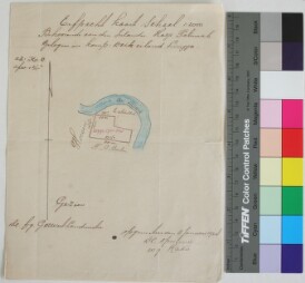
-
Map
Land Map and Land Record of Bangladesh Property.Extent: 1 Land Map.Size and dimensions of original material: The original volume with length of…
-
Official French Colonial Map of the Subdivision of Foumbot [01 Jan 1958]
Leaves: 1; Pages: 1; Measurements: 28.3cm x 23.3cm; Dates January 1958; Script: Roman script (for transcribing African place names); Condition:…
-
Map of Government Buildings with identifications in Bamum script and French
Leaves: 1; Pages: 1; Measurements: 17.3cm x 16.2cm; Dates Unknown; Script: Akauku Mfemfe and roman script (French language); Condition: Good;…
-
Gudalur Taluk Map
Gudalur Taluk, Nilgiri District Map. Scale 1 Inch = 1 Mile. Extent: This file containing 1 Map. Condition of original material: Map is decolored…
-
Map of unknown territory
Leaves: 1; Pages: 1; Measurements: 27cm x 23cm; Dates Unknown; Script: Akauku mfemfe and roman script (for Bamum); Condition: Poor; covered in dust…
-
Musil, Northern Arabia 1926: American Geographic Society Maps.
Accompanies the author's 4 works on northern Arabia, entitled Arabia Deserta, The middle Euphrates, Palmyrena, and Northern Neǧd, which were…
-
Spot where bones were found marked X.Map on card
Spot where bones were found marked X.Map on card.Extent: 1 file containing 1 page.Condition of original material: it has faded.Author(s)/Creator(s…
-
Map of the Shire Highlands showing the Estates devoted to coffee planting
Map of the Shire Highlands showing the Estates devoted to coffee planting.Extent: 1 file containing 1 page.Condition of original material: it has…
-
Ruo plan of Estate 1896 survey
Ruo plan of Estate 1896 survey.Extent: 1 file containing 3 pages.Condition of original material: they are Faded.
-
Chiromo Graves
Sketch Map of Port Herald Cemetery.Extent: 1 file containing 10 Pages.Condition of original material: there arePunched holes;Stained;Faded.Author(s…