Search results
Archive type
Content type
Related places
Languages
Scripts
Showing 1 to 13 of 13 results
-
Maps and drawings related to the cloister and Church of the monastery Dominicans of Santa Rosa in Santiago
Contains maps and drawings related to the cloister and the Church of the monastery Dominicans of Santa Rosa in Santiago, during the 18th Century.…
-
Maps of the monastery of Santa Rosa
Contains 6 maps of the Dominican monastery of Santa Rosa in Santiago, when it was located between the streets Amunategui, San Martin, San Pablo and…
-
Mapa de Bolivia y Norte Argentina por Pedro León de Santiago Alaves.
Regional map depicting Bolivia and northern Argentina, created by Pedro León de Santiago Alaves, with geographic and political details.Mapa…
-
Mapa de ruta Salaverry a Malabrigo
Drawing of a railway map whose route is Salaverry to Malabrigo.Dibujo de mapa de ferrocarril cuya ruta es Salaverry a Malabrigo.Extent: 1 Folio.…
-
Plano del combate de Matucana
Detailed maps of battles and South American regions, including territorial representations and engineering plans.Mapas detallados de batallas y…
-
Planos: "Proyecto de casa para Sancho Dávila".
Architectural plans for a house project intended for Sancho Dávila. Former reference code A36.Planos arquitectónicos para un proyecto de casa…
-
Plano de la batalla de Maipú.
Topographic and strategic map of the Battle of Maipú, showing troop locations, routes, and relevant geographical features for military planning.…
-
Planos de las minas Santo Domingo y Pennsylvania
Technical and topographic plans of the Santo Domingo and Pennsylvania mines, represented from all their vertices and perspectives.Planos técnicos y…
-
Mapa general de Sudamérica.
Broad map showing the political and physical geography of South America in a given historical context.Mapa amplio que muestra la geografía política…
-
Plano e información de la batalla de Vilcapuguio, realizada el 01 de octubre de 1813 entre el Ejército Nacional del Perú, dirigido por Joaquín de la Pezuela, y los insurgentes de Buenos Aires.
Document detailing the plan and information of the Battle of Vilcapugio, held on October 1, 1813, between the National Army of Peru led by Joaquín…
-
Plano de la Batalla de Chorrillos
“Map of the Battle of Chorrillos, January 13, 1881.” Copy of an original."Plano de la Batalla de Chorrillos, 13 de Enero de 1881". Copia…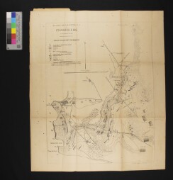
-
Carta geográfica de las campañas de Alvarez de arenales (1820-21).
Geographic maps illustrating military campaigns and strategic troop movements, providing valuable historical resources.Cartas geográficas que…
-
Map of Loma Rica
Map of Loma Rica.