Search results
Archive type
Content type
Related places
Languages
Scripts
Showing 1 to 9 of 9 results
-
Peta Sebidang Tanah [08 Jan 1924]
Site map for a land grant, 08 Jan 1924. Cartographer unknown. Watermark: MBS EXTRA FINE in shield.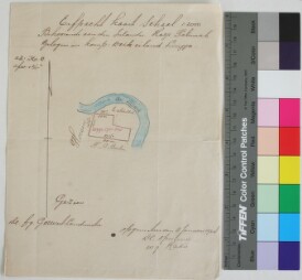
-
Kaart voor het Singkep Zeetin Concessie B
(Digital images of a map for a tinmine concession offshore near Singkep, Residentie Riouw. The map was received in a sleeve, together with EAP153/1…
-
Kaart der Mijnconcessie Koendoer Noord Afd Tandjoengpinang Res Riouw en Onderhoorigheden [6 May 1935]
Digital images of a map of a tin mine concession in the north of Karimun, Afdeeling Tandjoengpinang Residentie Riouw dan daerah takluknya. Created…
-
Peta Pulau Singkep
Map of Singkep island, date and cartographer unknown. Measures 41 x 38.5cm.
-
Maps (1695-1800)
Printed maps having relation to the region.
-
Peta Kota Dabo
Map of the town of Dabo on the island of Singkep, date and cartographer unknown. Measures 58 x 50cm.
-
Overzichkaart Karimoen [1 Nov 1954]
(Digital images of a map showing Karimun and tin mine locations. Copyist: C.KL.D.K.K., Date: 1 Nov 1954. Notes: A piece of paper folded in four…
-
Kaart voor het aanvraagen van de Singkep Zeetin Concessie
Digital images of a map of an offshore tinmine concession near Singkep. The information in the map is in Dutch. Folded map with in the middle on a…
-
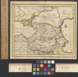
"Asia, Georgia, Armenia: Nieuwe Kaart van Geheel Georgië eertijds Colchis, Iberié en Albanië als mede van Armenië en medië Ասիա,Վրաստան, Հայաստան.Վրաստանի՝ նախկին Կոլխիսի, Իբերիայի և Ալբանիայի, ինչպես...
Rare map of the area between the Black Sea and the Caspian Sea. Contemporary colourin. Publisher: S.l, S.n.