Aims and objectives
During this pilot project a survey will be conducted to investigate the survival of so-called Thakbast maps in 20 Collectorate Records Rooms of selected districts in Bangladesh. The team will gather and list information only concerning habitation sketch maps of groups of villages (mouzas), which were pencil drawn by hand during the 1840s and 1850s in the former East Bengal (present day Bangladesh). In one District (Rajshahi) the team will undertake trial digitisation of the maps.
The number of historians studying agricultural Bangladesh is very limited. One of the reasons is the unavailability or poor condition of vital source material. The Collectorate Record Rooms in Bangladeshi districts do however still preserve some of this archival material that provides essential information to scholars interested in the village history of Bangladesh. The materials are often in a very poor state due to climatic conditions, lack of space, interest and/or due to sheer carelessness. In addition poor, outdated or no cataloguing systems are maintained. However, previous research indicates that some vital but endangered material still survives in these district records rooms. Maps that were generated during the early Thakbast Survey (1842-1860) constitute one part of such material.
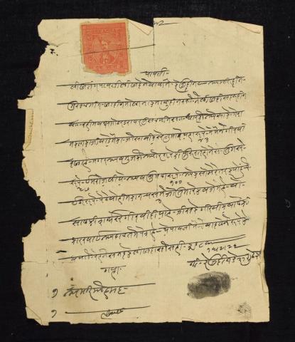
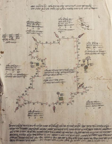
The Revenue Survey of 1846-1878 was preceded by a thakbast or demarcation survey in which the mouza (‘village’) gained legal status and became a basic survey unit. Officers were employed to demarcate on the ground the actual boundaries of ‘villages’ and estates before the revenue surveyor took to the field. For the purpose a rough map was compiled called the thak muzmilli. The vast majority of thak (boundary pillar) maps drawn before 1852 were eye sketches not intended to provide more than rough guidance to revenue surveyors. These were drawn by pencil whereas later maps were topographical and coloured. It is the hand-drawn Thakbast sketch pencil maps drawn during the 1840s and 1850s that have become rare and are not easily available now. These maps were prepared by an Indian Ameen accompanied by the British Settlement Officer and demarcated the mouza (village or group of villages, or lowest administrative unit) boundaries. In these maps the name of the mouza, area, type of soil, cropping pattern, number of population (religion wise), number of houses and cattle, location of roads, ponds, rivers, mosques, temples, hats, bazaar, indigo factories, big trees, etc. is indicated. In the corner, these maps also contain some map comments. These maps therefore provide first-hand information of rural Bangladesh during the early period of British colonisation in the inlands of East Bengal.
Thakbast Revenue and Cadastral Survey records are the earliest surviving documents of any kind of most villages in Bengal. Eminent senior scholars of colonial Bengal (including Bihar, Assam and Orissa) repeatedly refer to the importance of such maps in their work. In present-day Bangladesh however, little is known regarding their number, availability, physical condition and location.
These maps are part of a visual history of mapping in Bangladesh that also is part of a mapping of changing colonial rural East Bengal. They give historians an idea of shifting communal, economic, natural and socio-cultural factors in Bangladeshi villages. Apart from historians, other social scientists (in particular anthropologists and geographers), policy makers, archivists and even artists will support the preservation of these maps. Lastly, the region is neglected by scholars, and it is anticipated that locating, copying and listing these priceless maps will greatly stimulate researchers who are interested in agrarian history, to focus on Bangladesh.
The outcome from this project will be a survey report that not only lists these maps but also informs about the contexts and background of these early settlement maps that still survive in Records Rooms in Bangladesh. In Rajshahi district, trial digitisation and listing will be undertaken. This will all serve as a starting point to develop a future major research project proposal on ‘Mapping early rural East Bengal’ using the information obtained during this pilot project.
Outcomes
The records copied by this project have been catalogued as:
- EAP619/1 Rajshahi Collectorate Collection: Thakbast maps [1845-1850]
Due to the cyber-attack on the British Library in October 2023, the archives and manuscripts database is currently inaccessible and we are unable to provide links to the catalogue records for this project.